No edit summary |
(Adding categories) |
||
| Line 163: | Line 163: | ||
[[Category:Centre, Haiti]] |
[[Category:Centre, Haiti]] |
||
[[Category:Cities and towns of Haiti]] |
[[Category:Cities and towns of Haiti]] |
||
| + | [[Category:Agriculture production]] |
||
| + | [[Category:Sisal production]] |
||
| + | [[Category:Coffee production]] |
||
| + | [[Category:Tobacco production]] |
||
| + | [[Category:Sugarcane production]] |
||
| + | [[Category:Route D-305]] |
||
| + | [[Category:Communes with 5 neighbors]] |
||
Revision as of 18:13, 5 July 2020
"Fanm pa dra."
Women are not bed sheets.
-Haitian proverb
Las Cahobas (Kreyol: Laskawobas) is situated in the Central Plateau of Haiti. Both the Las Cahobas and the Senador rivers run through it. It is the principal city in the Las Cahobas Arrondissement. The city is noted for its proximity to the Dominican border and the Lac de Péligre, as well as its relaxed, friendly inhabitants. Approximately 10,000 people live in the center while the commune had a 2015 population of over 45,000 inhabitants.


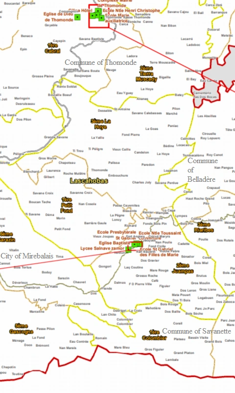
Location in Haiti
History
The area of Las Cahobas was first called Les Acacjoux (meaning "The Mahogany") by the Indian tribes which once lived there. It was founded in 1760 and granted municipal status in 1814.


Map of Lascahobas central area
About
Located 80 kilometers (50 miles) from the bottom of Route 3, Lascahobas (Les Acajoux by its Indian name) has remained a pleasant town despite the infrastructure problems it faces like electricity and wastewater drainage. Spanning 150 square kilometers, it has three communal sections generously stocked with historic and tourist sites. The English forts, Cerecite, Jacques ..., although abandoned today, provide information on the post-1804 defensive strategy which consisted in the creation and fortification of interior cities with a view to the eventual return of the French colonists. In terms of tourism, the Nan Remi cave, in the locality of Poulie, Nan Kafe, Nan Frechè and la Comb - a magnificent source, five minutes by car from the city center - are all assets that make Lascahobas one of the little-known pearls of Haiti. Far from the hustle and bustle, chaos and anarchy that prevails in the capital, this bowl-shaped city is an oasis crossed by five rivers that offer peace of mind. Jealously protected by thousand-year-old trees, Lascahobas has survived the poachers' furia. Baited by easy money, the vultures have thrown themselves on its precious mahogany trees, either to transform them into charcoal or to sell them in the form of boards. With several adjoining streets, the city center is crossed by a road which leads to Belladère, a town bordering on the Haitian-Dominican border. Lascahobas, one of the favorite crossing points of president Jean Pierre Boyer who ruled the whole island for 21 years, is a place of ethnic mixing. At every street corner, we come across Métis children, the fruit of stealthy copulations of the inhabitants of the two communities. Also, the Amerindian morphology of peasant women from Jumpas, Ti Fon, testifies to the presence of the descendants of the first masters, of the first occupants of the land of Haiti. A land that invites the transcendence of matter. A land which was nevertheless the scene of the first genocide of the "New World" perpetrated by raptor conquistadors thirsty for gold. At nightfall, Lascahobas is like a dead city. There is no electricity or distraction. Children are often confined to their homes. But for those who come from the chaos of the capital, the chirping of birds, the fresh air, the starry sky fill with happiness, with serenity. A known pleasure, therefore not exotic for Lascahobassiens.
But also a place to exploit in the perspective of the development of ecological and cultural tourism ...Lascahobas is a small pleasure to be offered.

Geography
According to the IHSI, the commune has a total land area of 151.68 square kilometers (58.56 square miles), of which 69.72 km² (46%) is rural, 81.11 km² (53%) is suburban, and 0.85 km² (1%) is urban.
It is bordered on the north by the towns of Boucan-Carré and Thomonde, on the east by the border town of Belladère, on the south by the town of Savanette, and on the west by the city of Mirebalais.
Lascahobas is an interior city with two communal sections. The dominant terrain of one its communal sections is the plateau and the other, mountains. The climate of the commune is classified as tropical savannah. In the winter, there is much less rainfall than in the summer. This climate is considered to be Aw according to the Köppen-Geiger climate classification. In Lascahobas, the average annual temperature is 25.3 °C (77.5°F). Precipitation here averages 1799 mm (71 inches).


Demographics The inhabitants call themselves Lascahobassien/ne.
| Year | Population | +/- |
|---|---|---|
| 1890 | 20,000 | |
| 1998 | 54,506 | |
| 2009 | 41,716 | -23% |
| 2015 | 45,873 | +9% |

The town center, valued at a third of a square mile (0.8 km2), has a population density of 13,001 inhabitants per square mile (12,236 inhabitants per km2).
Neighborhoods
| LAS | Las Cahobas | 45,873 | ||
|---|---|---|---|---|
| VLB | Ville de Lascahobas | 10,401 | ||
| PEF | 1ère Section Petit Fond | 15,164 | Barrière-Gaule, Bélotte, Bissainte, Blanchard, Boucan-Tache, Chapoteau, Déma, Gilbert, Gros-Morne, La Pêgne, Laurence, Loncy, Morin, Nan Cosole, Passe-Cayemites, Petit-Fond, Richard, Roche-Mulâtre, Savanne-Croix, Ti Savane, Vieux-Joupas. | |
| JPA | 2ème Section Juampas | 20,308 | Bois Miel, Bois Sèche, Brutus, Cadette, Café, Corail, Croix-d'Maryrs, Dalmas, Dos Gravier, Dos Leron, Dos Ti Bois, Dos Zaboca, F.D. Pierre-Ville, Figuier, Flande, Fleurissant, Fond-Cicile, Fonds-Bois Pin, Fort-Anglais, Gongori, Grand-Platon, Gros-Liane, Gros-Moulin, Grosse-Roche, Jacques, La Croix, Laq Coutine, Logabuen, Mare-Rouge, Mata-Pouert, Nan Baudrin, Nan Poulie, Parc Jn Parc, Ramier, Roche-Pabre, Sénador, Tibangoule, Verdun, Wampas. |
Economy


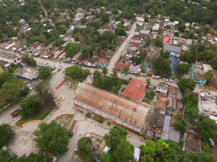
Central Park in Las Cahobas, Haiti
In the economic and financial infrastructure, the municipality has a hotel and five restaurants. On the other hand, it does not have a bank nor a credit union. The Lascahobassiens go to other municipalities to make their banking transactions.
Agriculture dominates the economy in Lascahobas. Local farmers produce coffee, sisal, tobacco, and sugar. Sold at the busy town market, the purchase of these products keeps commerce a vital force in the community. A primary reason agriculture booms in this town is the Lascahobas River, which irrigates farmland.
Infrastructure
Education


Lascahobas local school
The Ministry of the National Education for Youth and Sports is represented in the municipality by a school district office. Nine primary and six secondary public schools were inventoried in the municipality, along with numerous private schools.
In contrast, Lascahobas's school students can get on the solar-driven Internet, and also have availability of wifi at certain locations. This service has been provided to them by the Illinois Institute of Technology.
Health


Saint-Gabriel Medical Center
The Ministry of Public Health is not represented in the commune of Lascahobas. Two health centers represent the only health facilities in this commune. The Catholic Church, Saint Gabriel, operates the Lascahobas Hospital with the financial assistance of Friends of the Children of Lascahobas. Based in the U.S., it is a non-government organization dedicated to reducing high rates of starvation, illiteracy, and health problems of residents. In addition, a team of physicians, nurses, auxiliaries and health officers form the technical staff of these facilities.
Utilities

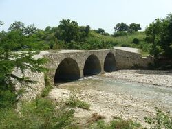
Las Cahobas River
As for water availability, five rivers and six sources have been inventoried. Apart from these water points, there are three artesian wells and some public fountains with at least six taps. Only the city of Lascahobas is electrified. This service is provided by L'Electricity d'Haiti (EDH). The frequency of feeding is on average 77 hours/week.
Lascahobas suffers from erratic electrical service. The government rations delivery of electricity to two days a week, but in the 80s and 90s the town was on the power grid 100% of the time. From 2006 to 2009, the town experienced a complete blackout. When violent protests broke out, the government turned the power back on.
Security
With regard to administrative and judicial infrastructure, the municipality has a peace court, a police station and an Office of Civil status. There is also a prison.


Las Cahobas road


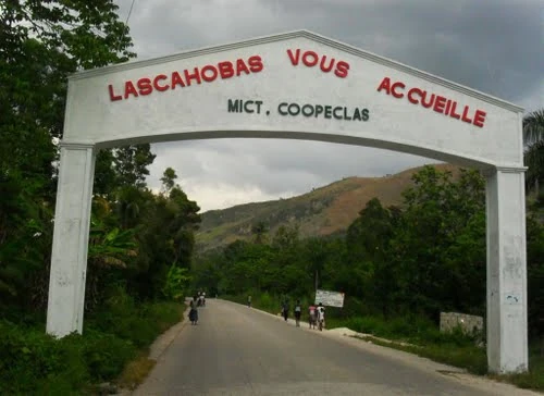
Ville de Las Cahobas

Culture
Religion
56 churches (chapels and temples included) were counted in the commune; However the number of Adventist churches is greater than that of other denominations (17 in total). Lascahobas's population is also largely Catholic, but it also has many believers of Vodun. They frequently hold festivals throughout the year in the foothills.
Organizations
As far as political parties and other organizations are concerned, they have gone: eleven Popular organizations, six peasant groups, three Women's groups and five NGOs.
Communication
The municipality of Lascahobas has four telephone booths. The postal Service is non-existent. It has two radio stations, but does not have a newspaper/magazine or television station.
Leisure


Las Cahobas waters
A library has been listed in the commune. However, there's no museum, no theatre, nor cinema. The number of Gaguères is fifteen. There are two public spaces and one private space. In addition to the monuments and listed sites in the municipality, several other places considered as places of relaxation or others have been reported.
")
")
")
")
")
")
")
")
Las Cahobas local map
References
Lascahobas - un petit plaisir [1] Michael Vedrine