"Di m kisa our renmen, ma di ou ki moun ou ye." Tell me what you love, and I’ll tell you who you are.
-Haitian proverb
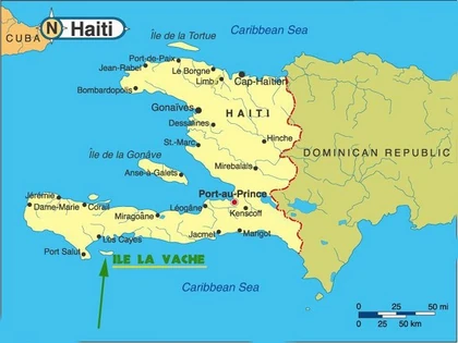
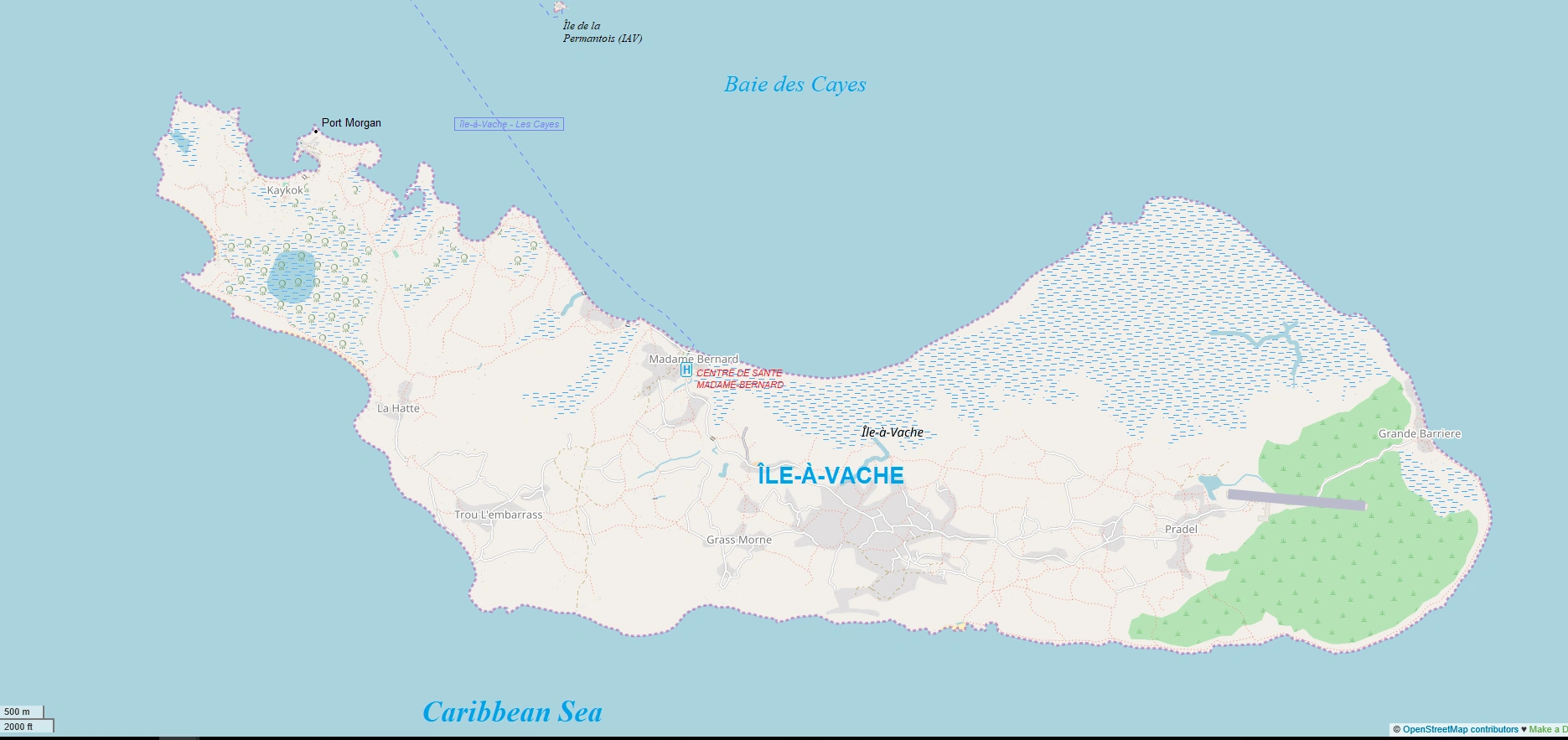
Île-à-Vache, (Spanish: Isla Vaca; English: Cow Island) is an island commune about 20 km (13 miles) by ferry south from Les Cayes, in the Southern Department of Haiti. It's sole communal section of the same name is coextensive with the Comnune of île-à-Vache, governed under the Borough of Les Cayes. As of the 2015 census, the population was 15,399.
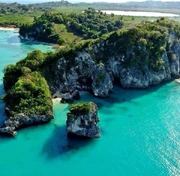
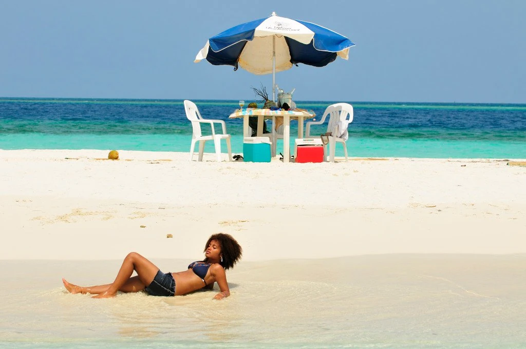
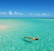
The modern media cites île-à-Vache's Abaka Bay Beach, located on the island's northwest side, as a tourist destination. It was designated as being the "57th best beach in the world". In 2013, île-à-Vache was voted number two (behind Port-Salut), by MondoBlog magazine, on its annual Top-ten list of the "most beautiful communes" in Haiti.

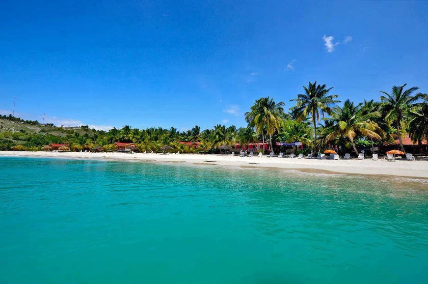
Abaka Bay Beach. ranked 57th in the 100 world's best beaches CNN list; Île-à-Vache, Sud, Haiti

Location in Haiti
Etymology[]
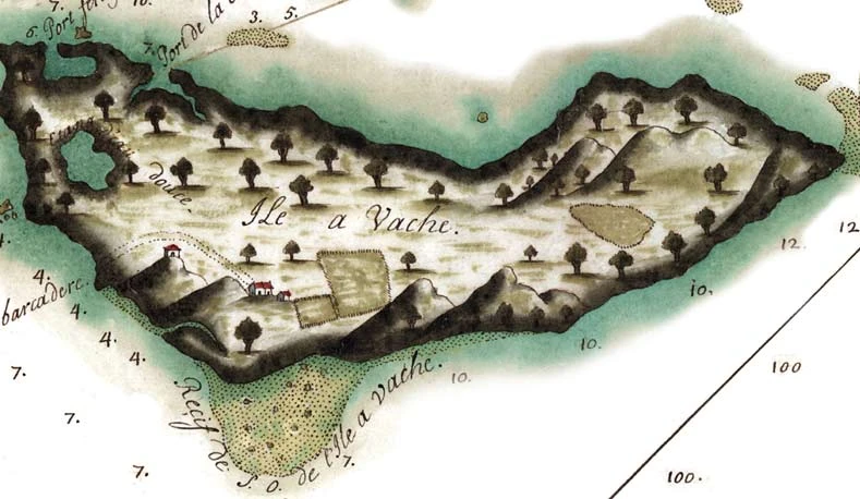
Its modern history goes back to the "discovery" of Haiti in 1492, when it was initially recognized as Spanish territory, until it was turned to the French after the Ryswick treaty of 1687 that ended a war between France and Spain. Over the course of two centuries, it served as a safe haven a for both Spanish and later the French settlers, known as buccaneers (or pirates), to safely raise their cattle, thus its name Isla Vaca (Spanish) or Ile-à-Vâche (French). The Buccaneers chose its name because of the high number of cows they discovered there. It was frequently used as a place of release for the pirates. The island's center is occupied by mounds, a pond, and is rich in guano and nanettes. There is chromium oxide.

Île-à-Vache c. 1700
The island was leased by the Government of Haiti in 1878 to Mr. Girard-Bastille. Food supplies are very successful. It makes a great butter. To the north of the island, there are several islets surrounded by reefs, the Cayes-à-l'Eau, ile au Grand Gosier, l’Ile à la Bourre, and la Folle. The Ile-à-Vache Canal is the strait that separates this island from the coast.
About[]
With a population of about 16,000 people and an untouched ecosystem, Ile a Vâche — about 12 kilometers (8 miles) long and 3 kilometers (2 miles) wide — remains again one of the rare havens that (so far) does not accommodate cars or other four-wheel motorized vehicles. At a mere 30 minutes from the wharf of Les Cayes, the third largest city of Haiti, its character hasn’t changed over the years. A Caribbean island, Île-à-Vache is Haiti's third largest island after Gonâve and Tortuga. The communal territory of Ile à Vache includes three small islets named Pierre le Nantais also called Pelantin, Cayes a l’eau, and Îlet le Brouet. It lies in the Baie des Cayes about 6.5 miles (10.5 km) off the coast of the country's southwest peninsula, roughly between the city of Les Cayes and Pointe l'Abacou. It was formerly known by the name of Abacca. Its inhabitants bear the name of Ile à Vachois. Administratively, it became a commune in 1976 as part of the Les Cayes Arrondissement in the Sud department.
History[]

Island of Cows, Haiti
Île-à-Vache is a relatively young community, founded around 1930 when Haitians from nearby towns on the mainland — such as Saint-Louis-du-Sud, Saint-Jean-du-Sud, and Torbeck — were attracted to the island to cultivate the land and to fish. The island was not previously forested until Senator Louis Desjoies arrived and rented the land from the state in the 1930s. He began planting lemongrass, lemons, millet, corn, and other agricultural crops, attracting people in large numbers. Around 1940, Father Robert Magron arrived and built the first city center and Catholic Church leading to further migration and Île-à-Vache becoming a district of Les Cayes.
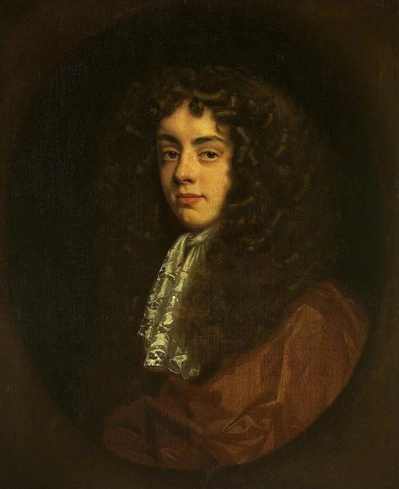

Portrait of Sir Henry Morgan, c.1680
17th Century: Captain Morgan[]
The history of Île à Vache dates back to the 17th Century (1600s) when the island became a haven for pirates. Henry Morgan, an English pirate, failed with his ship containing an important treasure, after a explosion at Baie Ferret opposite the current Kakok in 1668. The legend says that the booty of Captain Morgan's pirate team did has not yet been found. Following this episode, he settled on the island with his crew in the bay of Kakok.
Prior to this, "the abominable" Captain Morgan was famous because he undertook several expeditions in the Caribbean to attack the enemies of the English. When they were on the island, with the support of the English monarch, they continued to storm the Spanish ships trying to dock on the island. Over the centuries, the reefs surrounding Ile à Vache have indeed seen more than 200 ships ran aground, including the wrecks that are still buried in the depths.
18th Century: The first settlers[]
The first inhabitants of Île à Vache were from Saint-Jean-du-Sud, the town on the coast closest to the island. These pioneers arrived by boat and founded the village of La Hatte, which long remained the administrative center. There was built the first church and the first court. Providing for their needs, the inhabitants have grown vetiver, which was in high demand in Les Cayes. The island also turned out suitable for raising cattle, as the cows did not have anywhere to escape. During the course of this period, the island recieved its name due to the large number of cows and oxen that were there. The island was then gradually colonized from the southwest to the northwest, which offered bays protected from bad weather, and then ultimately toward the east. In each new village, the inhabitants have built a new church.
19th Century: Arrival of Bernard Kock[]
June 3, 1862, under the government of Fabre Nicolas Geffrard and with the approval of the American president of the time, Abraham Lincoln, an English entrepreneur named Bernard Kock has landed in Haiti with the objective of creating a cotton plantation on Île à Vache by providing black American workers to try to reproduce the same model that had been lucrative for him in Florida.

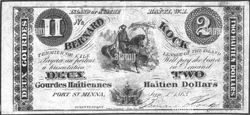
Île-à-Vache's currency during Kock's era
It was with great difficulty that B. Kock had received the agreement of the Haitian government to rent the island for a period of 10 years with the possibility of renewal. Once on the island, B. Kock created his own currency with which he paid the workers who could only spend it in his shops on the island.
Despite all the promises that had been made to him by American investors, as well as the President Lincoln, the project failed and President Lincoln had to send a ship to recover the 500 former American slaves who had been settled on the island.
During this period the villages of Madame Bernard and Kakok were born. Madame Bernard derives its name from the wife of Bernard Kock, who left a good impression on the inhabitants of the island, thanks to the charitable activities she practiced in the zone. The locality of Kakok derives its name from the expression in Creole “lakay Kock”, that is to say, "Kock's house."
20th Century: Father Magron[]
A key character for the evolution of the island is the priest Robert Magron, born in Petit-Goâve to a Christian family. Throughout his childhood and his youth, he lived in the city of Jérémie, where his father was a native. After his studies at the Saint Martial College in Port-au-Prince, he went into Saint-Jean-du-Sud as parish priest under the ordinance of Bishop Kolinyon.
One day, he asked the bishop to transfer him to Île-à-Vache. Thus, on May 5, 1959, Robert Magron arrived on the island. This religious leader has built several chapels and next to each chapel a school. The first chapel, called Gwo kay, was built in the locality of La Hatte. He also founded the Sainte-Anne School in Mme. Bernard, which no longer exists today.
The priest Magron also undertook construction works for a stone road in order to connect the two ends of the island more easily. According to the testimony of several residents of the island, Robert Magron was not only a religious leader, but also a father and a friend, and he continues to be recognized and respected from generation to generation.
• S.E.M. de Voltaire Castor was Count of the Île-à-Vaches, under the Empire in 1849.
• August 6, 1909 the house erected the island of Île-à-Vache to a district.
• A lighthouse was installed in April 1922. The projections are visible at 9 miles.
Beginning in the 1950s, people received farming rights and rural grants from the central government to become landowners. People brought vegetation to plant—such as coconut trees and mango trees, and residents take great pride in having created the notable landscape and scenery.2 The island was featured by Cable News Network in 2017 as having the world’s 57th most beautiful beach, Abaka Bay.
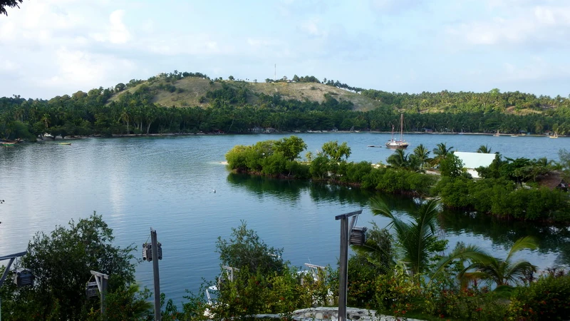

View from Port-Morgan; Île-à-Vache, Haiti
Geography[]

Port-Morgan; Île-à-Vache, Sud, Haiti
According to the IHSI, the commune has a total area of 45.96 square kilometers (17.75 mi²), of which 44.66 square km (97%) is suburban and rural and 1.30 square km (3%) is urban. It is both the tenth smallest commune in Haiti by land area and tenth-smallest by population. Administered under the Southern Department, its land acreage, a very green island with plenty of swamp areas, containing 10,000-15,000 occupants, is said to be the most scenic place in the entire Caribbean region. Two resorts on the island attract the tourist trade: Abaka Bay and Port Morgan. The triangular region of ocean between Île-à-Vache, Pointe de l'Abacou, and Les Cayes is Baie des Cayes. The highest point on the island is the hilly area in the western section, about 50 (200 ft) above sea level.
Neighborhoods
| IAV | Île-à-Vache | 15,399 | |||
|---|---|---|---|---|---|
| Ville de Île-à-Vache | Urban | 2,066 | |||
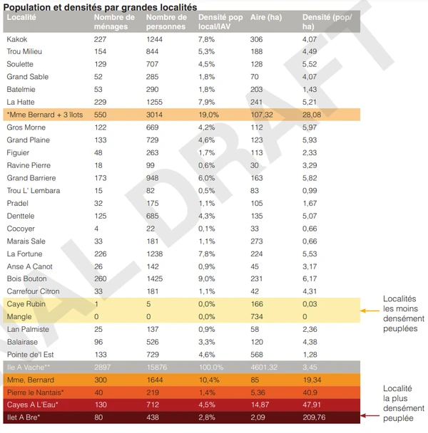
| IVA | 1ère Section Île-à-Vache | Rural section | 13,333 | Aux Palmistes, Bois Boutou, Boutte, Cacoq, Grand-Barrière, Gros-Morne, La Hatte, Mme Bernard, Pradel, Richard, Roche, Trou l'Embaras |
Demographics[]
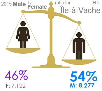
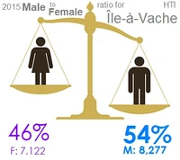
According to a 2015 demographic study by the IHSI he total population of the municipality of Île à Vache is estimated at 15,000 inhabitants. This represents only 2% of the total population of the South Department and 0.14% of the total population of the country. It is an island that is not very urbanized, with only 13% of residents living in urban areas.
The adult population (18 years and over) is the majority (56%) and is close to that of the country which is 58%; on the other hand, the municipality of Les Cayes' 18 and over population is greater than 61%.
The size of households in the municipality, which is 5.48 is higher than that of Les Cayes and the country, which are respectively 4.8 people / household and 4.6 persons/household.
The population is relatively very young.
38% of its population is under 18 years old
56% of its population is aged 18 to 64
6% of its population is aged 65 and over.
| Year | Population | % +/- |
|---|---|---|
| 1998 | 12,289 | |
| 2009 | 12,306 | +14% |
| 2012 | 14,695 | +19% |
| 2015 | 15,399 | +5% |
Much of the town's coastline is occupied by mangroves. Despite the frantic race to obtain wood for charcoal and construction, the mangroves still occupy nearly a quarter of the entire municipal territory. Although the northeast part of the island is occupied by a large mangrove surrounded by wetlands, the northeast part is characterized by a relatively dry area with rocky outcrops and brush or dry forest. Except the dry zone and the large zone of mangroves located in the eastern part of the island, the other areas are covered with relatively dense diversified vegetation. The built surface covers almost 7% of the territory. The majority of the inhabitants of the island are farmers and/or fishermen, which means that the agricultural culture occupies most of the territory, nearly a third, and this is essentially concentrated in the central part. The breeding areas are mainly concentrated in the southern part of the island, near the coastline. They occupy just over 5% of the communal territory. One can also notice a relatively large presence of fruit trees, which cover nearly 11% of the territory with a higher concentration in the west of the island. The dominant fruit trees are: the coconut tree, the almond tree, the mango tree, cashew nut and real tree. The western part of the island is characterized by a relatively hilly relief, with the presence of a large lake surrounded by a mangrove.
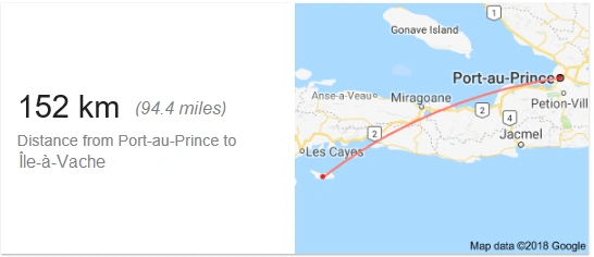
Lying off the south-western end of Haiti, Ile a Vache is located 3 leagues (10 miles) to the south-southeast from Downtown Les Cayes, which is the regional center of the south of the country. Local development hubs Saint-Jean-du-Sud and Saint-Louis-du-Sud are located respectively at 19 km and 24 km across the bay from the island. Other major cities of the country are relatively remote; Port-au-Prince 152 km and Jacmel at 119 km.
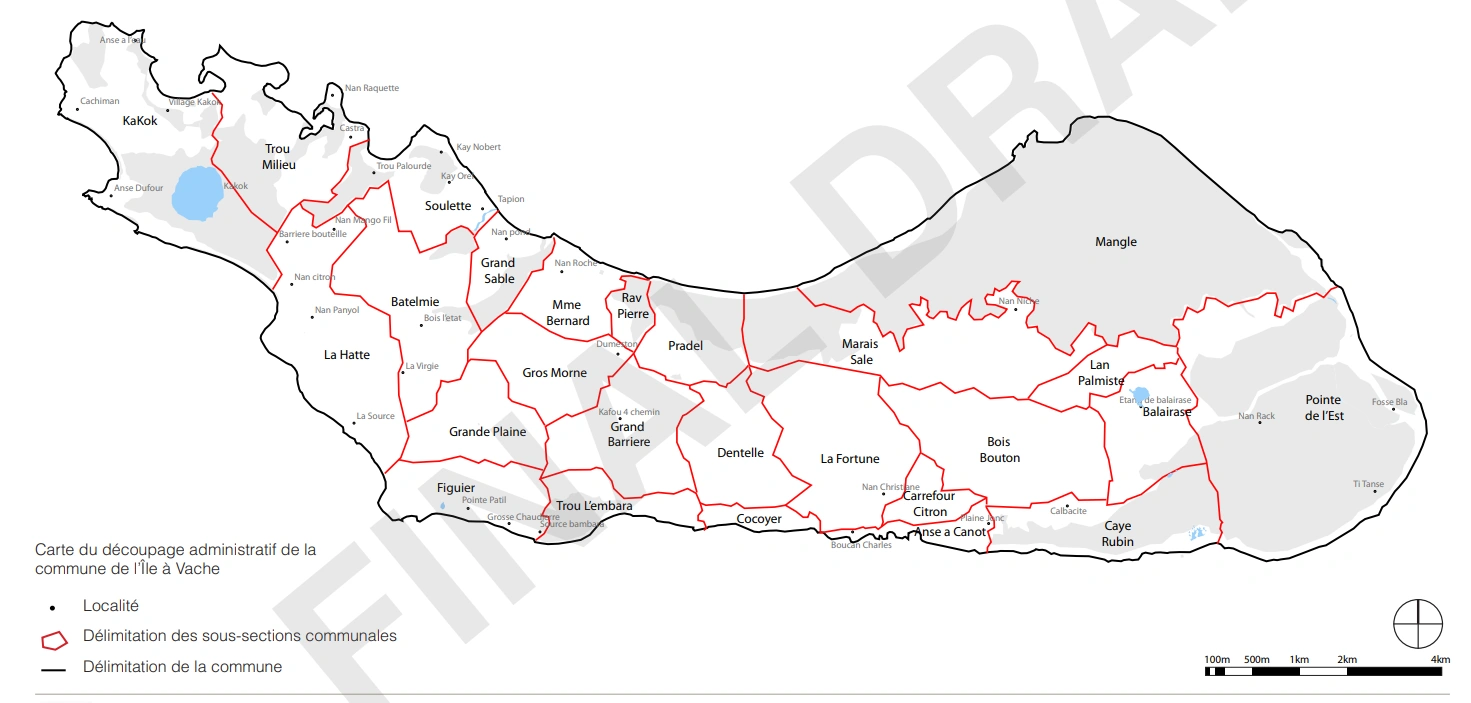
At the administrative level, Île à Vache consists of a single communal section which bears the same name as the municipality. The inhabitants and the town hall find their bearings on the land thanks to a division that subdivides the island in 26 parts, these are habitations that locally are called localities or large sub-sections (see map above). The three small islands are included in subsection of Madame Bernard, which is the administrative and economic center of the community. The limits of the 26 habitations, as indicated in the plan, reflect the perception of the territory by the inhabitants and the authorities. Although drawn up with the most care and as faithfully as possible, these limits may vary because they have no official status.
Locals also say the town is subdivided into 4 large areas, each of which encompasses different sub-sections.
Terrain[]
The profile of the municipal territory is marked by hills, plateaus, valleys and coastlines. The relief of the area varies from zero at sea level to 75 meters (246 feet) above sea level on the summit of the subsection of Kakok. The hills and mounds have slopes that vary from 20% to 50%.
The western part of the island is mountainous with a point towering 75 meters (246 feet) above sea level and is located in the subsection of
Kakok. The hills continue and descend from the center of the island to the east and divide the north and South. The eastern part of the island is relatively flat with small hills in the center. The lowest points on the island are located at Point Est and Mme. Bernard. On the western part of the island there are five large hills:
• In Kakok, Do Kachiman with 75 m height,
• Between Soulette and Batelmie, Morne Kay Mira with 55 m (180 ft.) height
• Between Grande Sable and Batelmie, Morne Bwa Leta, with 45 m (150 ft.) height
• Between Mme. Bernard and Gros Morne, Morne Citadel with 65 m (215 ft.) height
• At La Hatte, Morne Kay Klercide which measures 50 m (165 ft.)
Hydrographic[]
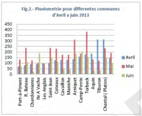
Regional rainfall chart
There is no permanent river on the island. The permanent water surface is the large lake located in the west part, which occupies just over 1% of the territory.
The eastern part of the island is indeed very humid, except the large mangrove area at Mangle. Many small streams cross this part of the island. Madame Bernard is very sensitive to flooding, on one hand, because of its low level relative to the sea. When the sea rises, the part of the city near the public square is practically impassable because of mud. On the other hand, the city is surrounded by two streams which, during heavy rains, create relatively large floods.
The Balairase area also suffers from severe flooding due to the lake of Balairase, which swells in the rainy season.
Economy[]
At the level of Economic and Financial Infrastructures, a hotel, a reception center for foreigners and a credit union have been listed on Ile à Vache. With regard to commercial establishments, the municipality has only two food supply centers. There is no gas station, no private morgues, and no hairdressers. There is only one pharmacy.
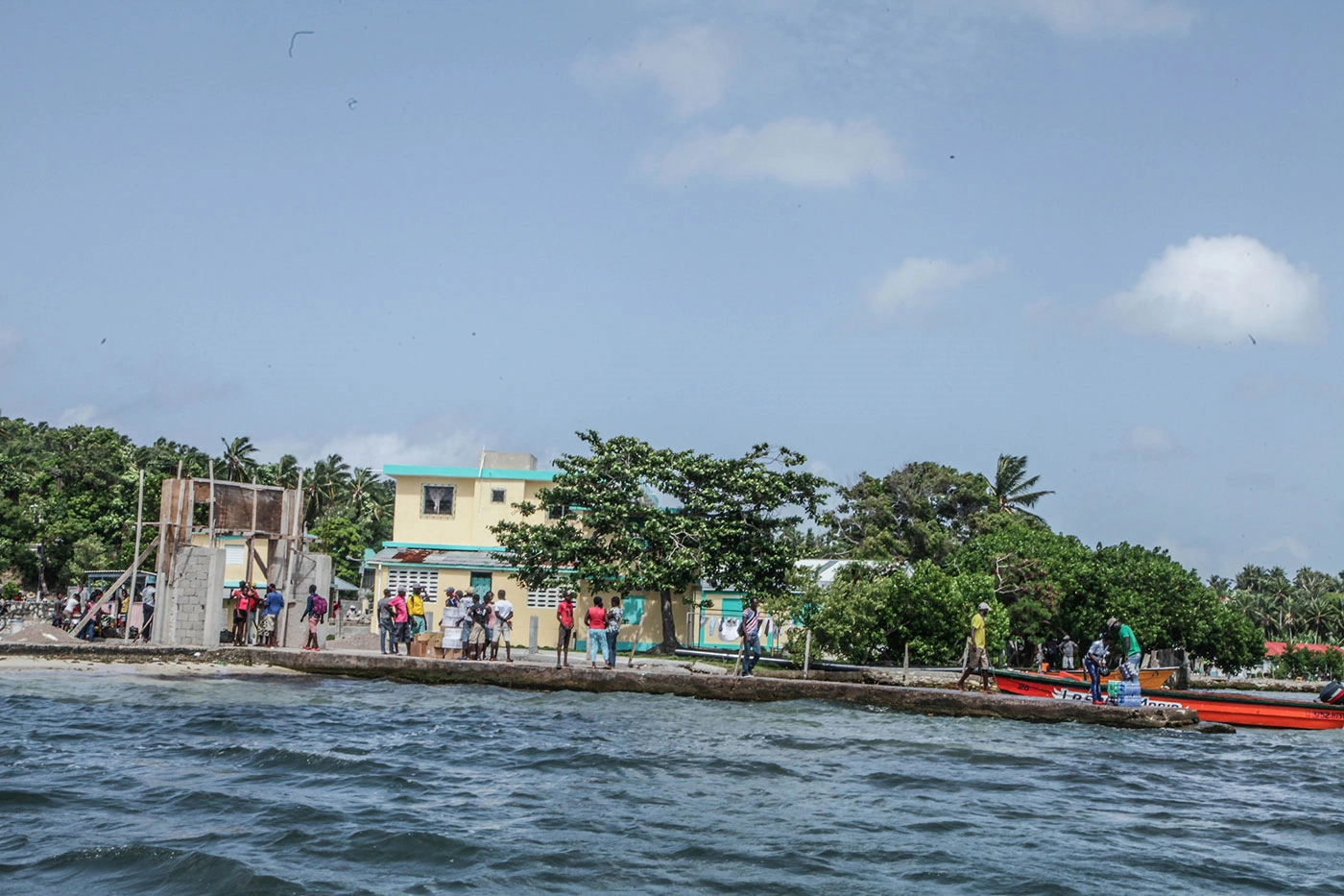
The economy of the island is largely informal and sustenance based. The primary commerce center on Île-à-Vache is located in Madame Bernard, the most populated locality. Market stalls line the beach filled with vendors offering a variety of goods. The market is located next to the mayor’s office, which collects a small annual fee from the vendors to reserve a stall. Products sold include food (fruits, vegetables, meat, fish, poultry, grains), clothing, shoes, electronics, cosmetics, alcohol, cooking ware, miscellaneous household goods, and small farm animals.
The market only operates twice a week and no other organized commerce exists on the island; business is primarily conducted in Les Cayes. Beyond commerce and trade, fishing and agriculture are the primary means of sustenance, but are limited by a lack of machinery and modernization.
Infrastructure[]
Ile-a-Vache's ferry
Transportation
Although coastal, the town has no formal port. About a hundred sailing boats frequent the coast of the municipality carrying passengers, goods and sometimes drinking water.
Education
The Ministry of National Education of Youth and Sports is not represented in the Municipality of Ile à Vache. One kindergarten, five primary schools, two secondary schools and a technical and vocational center have been identified on Ile à Vache.
Health
The Ministry of Public Health and Population is not represented in the commune of Ile à Vache. A health center without a bed was inventoried with a few nurses, auxiliaries and a certified matron.
Utilities
The Ile à Vache confronts many difficulties with regard to water resources. The inhabitants dig wells to be able to find water and sometimes they source in other communes like Les Cayes for example. At the time of the inventory, the town was not electrified.
Security
The National Police of Haiti is not represented in the commune of Ile à Vache, there is a court of peace and a registry office; there is no prison.
Culture[]
Religion is a focal point for the population. The inhabitants belong to different religious groups such as Catholicism, Vodun, and Protestantism among others. There are churches and Voodoo peristyles all over the island.
The music played and danced the most is Rara Congo, Menwat and Folklore. There is a place in Madame Bernard where you can find shellfish in very large quantities. The local population believes that this place was inhabited by Indians.
Participants recognized the value of their culture and history, and saw potential for showcasing this local character within the framework of tourism development. They listed developing tourist sites and organizing cultural activities in the town as possibilities, with support from the Haitian State and the international organizations.
Religion
The town has four Catholic churches (including chapels), five Baptist, two Pentecostal and seven other churches.
Organizations
There are five community-based organizations representing over 300 individuals in L’Ïle-à-Vache, serving women, orphans, and tourism.
Communication
There is no postal service in the municipality. There is also no radio station, newspaper / magazine, nor television station.
Leisure
As for Leisure, the town has no library, nor museum. There is a theater room that can hold nearly 800 people. Football (soccer) is the only sport practiced in the municipality. In addition, the town celebrates its patron saint every last Sunday of May.
Getting to Île-à-Vache[]
One alternative to flying is to rent a good SUV – average of $60/day - to make the four hour drive from PAP to Les Cayes. Public transportation is also an option: air-conditioned minibuses are available at affordable $10 – one way. At the Les Cayes bus station, cabs take visitors to the wharf for less than $2.
Usually the visitor would make prior arrangement to be picked up by a small speedboat at the wharf, to cross the 7 miles in some thirty minutes before arriving to one of the three resorts. Price may range from $30-40 for a one way ride or at a lesser price for groups, but once on the island, the magic begins.
Tourism[]
For adventurous minds, Ile-à-Vâche may mean the ultimate discovery of a pristine island surrounded by emerald-like waters disrupted by gentle bubbling waves that go on to crash against bands of fine white sand that circle the island. On the velvet green grass that covers most of the island, indolent cows munching on the grass, hyper active goats and other farm animals seek shelter against the sun, under tall coconut or mango trees that move their branches as if shuddering under the caress of the breeze
Ile-a-Vâche, a tiny 20 square mile piece of paradise in the Southwest of Haiti has been captivating the imagination of curious or daring travelers for years. Considered one of the most romantic get-aways in the Caribbean, Ile a Vache Abaka Bay represents a Garden of Eden for sensualists, who marvel at its sugar-white beaches and verdant mountains, and valleys brimming with tropical vegetation. Livestock roam freely, grazing on vast grasslands.
Whatever the motivation, a tour in Ile a Vâche offers a variety of options for the tourist in search of a good leisure time or of a stimulating social and community experience. The 7-mile-long island offers some great car-free paths that take the visitor toward the top of various soft hills from where one can enjoy some fascinating scenic views: Large swaths of green space similar to a natural golf courses, colorful little ajoupa covered with hays, indolent cows chewing on the wet grass, or residents heading to the fields or the market.
While the island has retained its natural beauty and ancient way of life, it features more modern lodging accommodations thanks to (named after the infamous Captain Morgan) Port Morgan, Abaka Bay, and the community-oriented Vacations Village / Village Vacances which has roots in Massachusetts (home to its first investors). Across the three sites, visitors’ choices are rather rich: sailing, diving, swimming, boat tours, speed boat practice, inland guided tour, kayaking, volleyball, community soccer. They can also venture in the nearby Island of Love said to be exclusively for romantic tête-à-têtes, or to the Fishermen’s’ Island for some time fishing or interacting with local fishermen. One old fisherman demonstrates his savvy staying 10 minutes under the water and sometimes triumphantly bringing a fish in his bare hand!
The plans by the Haitian government to make of Ile-à-Vâche an ultimate Caribbean resort have resulted in controversies due to fear of relocation by the locals. According to some accounts, their fears include an initial lack of communication with the locals and potential damage to the ecosystem, along with concerns about social and economic reengineering in the once quiet and bucolic island. There have been some first steps to address these issues, however regardless one’s position on such plans, Ile-à-Vâche is not about to change soon.

Île-à-Vache, Haiti
Folklore[]
The natives of Ile a Vache are welcoming, willing to share the folklore of their region with curious visitors. According to the townspeople, at one time a madly-in-love couple, visiting the island, became enchanted with it, re-settling there. They built schools, started healthcare clinics, and provided a school-lunch program for the island's children. But over time, the couple fought bitterly and moved to opposite ends of the island, where they continued their humanitarian works separately. The townspeople since that time have referred to these parts of the island by their benefactors' names: Cox-town and Bernard-place.
References[]
"Caractéristiques générales de la commune" - EDEM [1]
"Île-à-Vache" - Haiti Observer [2]
Ile a Vache [3]
"Development Strengths and Opportunites" [4]
Michael Vedrine