"Byen pre pa lakay."
Being close does not mean you are home.
-Haitian proverb


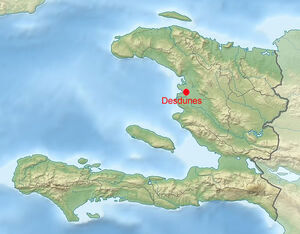
Location in Haiti
Desdunes (Haitian Creole: Dedin) is a commune that is part of the Dessalines Arrondissement in Haiti's Artibonite Department. It is located in the great Artibonite Plain, in the heart of the rice granary of Haiti. The population was 37,027 at the 2015 census. Rice production is the driving force of the local economy.


About[]
This commune is located in west-central Haiti's Artibonite Plain 32 km (20 miles) north of Saint-Marc and 19 km (12 miles) south of Gonaïves. Being partly surrounded on the west by coastal wetlands, Desdunes offers possibilities to observe the natural marshes and mangroves that flow to Grand-Pierre Bay, which defines the boundary between the coastal plain and the vast Gulf of Gonâve. The eastern portion of the town is mostly made up of agricultural land.
Desdunes was formed as a commune by an act of the law of 1983, when it broke away from the town of L'Estère. Long before the town was incorporated, the residents known the area as "Ti Desdunes". Ti Desdunes was originally the second communal section of Gonaïves; Ti Desdunes also served as a military post for the Gonaïves Arrondissement.
Desdunes is an essentially agricultural community, but the farmer's tools are very basic (machete and hoe) and the crops are dependent on unpredictable weather. Six, seven or eight months may go by without a drop of rain falling in this arid region due to the constant drought.
The distance from the main part of Desdunes and the Gulf of Gonâve (about 16km (10 miles)) is not very far. As a matter of fact, people can already see and witness the beauty of the sea when they are in Desdunes.

History[]


Rodolphe Desdunes in 1911
History
The establishment of Desdunes dates back to the era of French colonization, when the Rossignol family, who were prominent industrialists in the region, owned various enterprises such as cotton and coffee plantations. One member of this family, Louis Rossignol Lachicotte Desdunes, who owned a cotton field, bestowed his name upon the town.
Desdunes was originally settled as a village within the boundaries of Gonaïves, under the name Ti Desdunes, which the area was already known as, long before founding. After serving as a military outpost of the Gonaïves District, Ti Desdunes became the second communal section of the City of Gonaïves, until 1983 when it was granted municipal status and renamed Desdunes.
Under the leadership of General Henry Namphy, the municipality of Desdunes was divided into four sections, and within this area, there are 6 community districts that define the administrative profile of the town: Duclos and Model (1st section), Grand-Islet and Hatte-Desdunes (2nd section), Aux-Sources Sud (3rd section), and Lagon-Penyen (4th section).
In December 1990, many changes were made to the administrative structure of the area. Thus, three of the four sections were eliminated. Only the second section (Grand-Islet and Hatte-Desdunes) was authorized to participate in the elections of December 16, 1990.
Geography[]

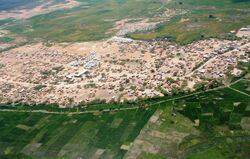
Aerial of Desdunes
Desdunes is located at 19.2894° N, 72.6417° W. The eastern boundary of Desdunes is Route Nationale 1.
According to the IHSI, the commune has a total area of 99.49 square kilometers (38.41 square miles), of which 93.37 km² (94%) is rural and suburban and 6.12 square kilometers (6%) is urban. It borders L'Estère to the north, Dessalines to the east, and Grande-Saline on the south.
The town's population is largely concentrated in the locality of Lagon-Penyen, which had a 2015 population of 26,952 inhabitants or 76% of the total population of the municipality. The rest of the population lives in localities distributed around Lagon-Penyen, mainly in the eastern part of the municipality. In total, 81% of the population lives in urban areas compared to 19% in rural areas. Housing is therefore concentrated in a few towns, the rest of the space being almost exclusively devoted to agricultural activities (to the east), and to wetlands and mangroves (to the west).
This population is experiencing a significant rise, as it grew by over 10% between 2003 and 2008. This growth can be attributed to a relatively high population increase of approximately 17% per year, as well as immigration from Gonaïves, driven by the municipality's thriving agricultural sector. Desdunes, in particular, is among the top destinations for migrants, similar to other areas in the Artibonite Plain, and the impact of immigration is considered substantial.


Neighborhoods
| DED | Desdunes | 37,027 | |||
|---|---|---|---|---|---|
| VDD | Ville de Desdunes | Urban | 33,222 | ||
| DDU | Rural section | 3,805 | Au-Source-Sud, Bois-Gerard, Chevreau, D'accuel, Duclos, Duclos-Desdunes, Grand-Lagon, Grand-l'Islet, L'Acul, La Hatte, Matelas, Modelle, Savane, Trou-Caïman, Vieux-Pilon. |
Neighboring sections
|
|---|
Desdunes is made up of a number of neighborhoods:


Desdunes High School under construction;
Nouvelle Desdunes
• East of the geographical center of town is Desdunes. Desdunes is four kilometers from L'Estère which can be reached by a path in one hour of walking. It is roughly defined by the Desdunes Canal to the north, Rue Coloniale and Rue l'Hôpital to the east, Avenue Marie-Jeanne, along which runs l'Estère Canal, to the south, and Rue Nouvelle-Desdunes to the west. The zone consists of the Nouvelle-Desdunes, Lakou-Baptiste, Rasta, and Descarreaux neighborhoods.

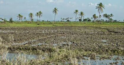
Rice fields; Duclos
• Duclos is located at across the canal from the south end of the Nouvelle-Desdunes Road. It is located along the Duclos canal.


Aerial view of Modèl
• Modèl is a settlement in the southwest corner of the commune, near the border with Grande-Saline. Together with Duclos, the two represented Desdunes' original 1st communal section.


Aerial view of Hatte-Desdunes
• Grand-Islet, coupled with Hatte-Desdunes, formed the 2nd section.
• Aux Sources Sud runs along the banks of Rivière l'Estère. It's northern portion falls between l'Estère River and the l'Estère border line.
• Lagon-Penyen is a community that was once Desdunes' 4th section. This locality, which has a population of 26,952, or 76% of the population the municipality, has the highest concentration of residents in the commune.
Demographics
The inhabitants are called are called Desduniensm and Desduniennesf .
| Year | Population | |
|---|---|---|
| 1998 | 29,333 | |
| 2003 | 42,000 | +30% |
| 2009 | 33,672 | -16% |
| 2015 | 37,027 | +10% |
The gender ratio is 96 men for 100 women. Almost 70% of the population of the municipality of Desdunes resides in urban areas. During the 1982-2003 intercensal period, the annual growth rate of the population was 1.4%.
The distribution of the municipality's population by major age group has the following structure:
35% of its population is under 15 years old,
60% of its population represent people aged 15-64, and
5% are aged 65 and over


Modèl Habitaitons


Vacant lot at Ville de Desdunes


Modèl
Climate[]
The commune of Desdunes enjoys a dry tropical climate, with an average temperature of 26.5 ° C (80F°) and low rainfall which does not exceed 700 mm (28 in) per year on average.
This climate is characterized by two seasons:
• A dry season that runs from November to March with temperatures fluctuating around 25°C (77°F) in the dry season and very low rainfall reaching its lowest level in January with an average of 6 mm (0.25 in).
• A rainy season that extends from April to October, temperatures of about 28°C (82°F) and higher rainfall levels, reaching their highest level during the month of June with an average of 98 mm (3.8 in).
The town's climatic conditions can be attributed to its geographical location. Situated west of the Black Mountains and south of the Northern Mountain Range , Desdunes experiences a unique weather pattern. Clouds carrying moisture from the Atlantic Ocean are pushed by the trade winds from the northeast to the southwest. As these clouds encounter the slopes on the east and north sides of the mountains, they are forced to rise in altitude. This ascent leads to lower temperatures and pressures, resulting in condensation and precipitation. However, on the other side of these mountains, where the town of Desdunes is situated, the air lacks moisture, leading to minimal rainfall.
Hydrographic Network
In addition to these challenging weather conditions, the municipality is characterized by a relatively inadequate natural hydrographic network, which is defined by the Rivière l'Estère and its tributaries. These waterways are primarily fed by rainfall from the Black Mountains situated to the east of the town. The topography forms awatershed that directs the runoff water towards the watercourses supplying the L'Estère River, which acts as the boundary between the communes of Desdunes and L'Estère.
The municipality of Desdunes benefits from an artificial waterway that diverts water from the Artibonite River, enabling the irrigation of vast areas of its land. The town is fortunate to have access to both natural and artificial waterways. The natural hydrographic network leads to the sea at Baie de la Tortue, with an average flow of less than 3 m3 / s (3,000 liters, or 800 gallons, per second). On the other hand, the artificial channels are powered by the rivers of Estère and Artibonite, with the latter being Haiti's fastest flowing river at 99 m3 / s (99,000 liters, or 26,000 gallons, per second). These channels cross the entire commune of Desdunes from east to west and open into the Bay of Grande Pierre.
The commune, situated on the Artibonite Plain, is characterized by a very low altitude (about 8 meters (26 feet) above sea level), lack of hills, and by the existence of flood zones and mangrove swamps that act as a protective barrier between the sea and the land. Nevertheless, the plain is encircled by majestic mountain ranges: The Chaine des Matheux to the south, the Black Mountains to the east and the Massif du Nord to the northeast.
Soils
The commune's soils are of relatively low quality, corresponding to 5th grade soils at best, which are suitable for pasture and rice cultivation, providing high productivity with proper management. However, they are not conducive to other types of crops like the higher soil classes (ranging from 1 to 4). These 5th category soils span across 4009 hectares (40 sq. km or 15.5 sq.mi) in the eastern part of the commune. It is important to highlight that these soils are generally affected by salinization, which leads to their degradation.
The 6th category soils, located in the center of the commune and covering 197 hectares (2 sq. km or 0.75 sq.mi) are designated for forest and pasture use; due to their shallow depth and uneven terrain, these soils have limited potential for agricultural purposes.
Soils of the 7th category cover area of 2015 hectares (7.77 sq.mi)and are mainly based on the central area of the commune; these soils are not culturable and should only be intended for restières. Finally, the 8th category soils cover as for them a surface of 3628 hectares (12.6 sq.mi) and are located exclusively on the fringe west of the town, near the sea; these soils, located in the mangrove area and swamps, should only be used for environmental protection and can not welcome production activity- agricultural or forestry.
7th category soils cover an area of 2015 hectares (20 sq.km or 7.77 sq.mi) in the central area of the commune, deemed unsuitable for cultivation and reserved for restières. On the other hand, 8th category soils cover 3628 hectares (32.6 sq.km or 12.6 sq.mi) exclusively in the western fringe near the sea, within the mangrove and swamp regions. These soils are strictly reserved for environmental protection and are not suitable for any agricultural or forestry activities.
Given its geographical location on a large plain, particularly downstream from fertile soil, the town of Desdunes faces a significant risk from rainfall, which has the potential to result in both floods and droughts during adverse weather conditions.
Economy[]

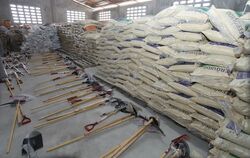
Discounted fertilizer in Desdunes
Regarding the Economic and Financial Institutions, there are no banks in the municipality. The Desduniens have to visit neighboring communes for their banking needs. However, the town does have three restaurants, a credit union, and a marketing cooperative. The inventory of commercial establishments in the town reveals that there are nearly 200 businesses, with 75% of them being small shops. These small shops cater to retail sales and are supplemented by four larger stores and a supermarket. Furthermore, the town is home to 18 bars and restaurants, seven pharmacies, five construction material stores, and two vehicle parts shops. Additionally, there are 16 exchange offices, 48 borlette banks, and approximately 43 business houses. Trade is the primary economic activity for the residents of Desdunes, although agriculture, particularly rice cultivation, also holds significant importance in the town.
Local trade is carried out in part at the markets of the municipality, the main ones of which are in Duclos and Lagon-Penyen. However, the majority of agricultural products from the municipality are sold in Estère. According to a survey, 90% of merchants stated that they sell their products in L'Estère, the neighboring town, which benefits from direct access to the national road network.
The continuous drought and water scarcity have led to the uncultivated soil in Desdunes. Residents resort to seasonal work in the rice fields of L'Estère due to the lack of water supply. The population faces chronic food shortages, resulting in impoverishment and forcing many to leave the small town in search of food or employment in urban areas. Goat farming is rare, and when it does occur, it is typically done at the family level.
The town is witnessing a rise in micro-manufacturing enterprises specializing in the production of rice straw briquettes, with the aim of substituting traditional charcoal usage.
Tourism[]

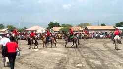
Horseback riding
The town currently lacks a thriving tourism industry, with only one hotel listed in the area. However, the potential for growth is immense and largely untapped. The commune boasts the second largest mangrove area in the country, surpassed only by Caracol Bay. Spanning 7,328 hectares, the mangrove area stretches from the Bay of Gonaïves to Pointe des Flamands, with 46% (or 3,352 hectares) falling under the jurisdiction of Desdunes municipality. This makes it the most densely covered mangrove area in all of Haiti, followed by Limonade (2,900 hectares) and Caracol (2,700 hectares). This exceptional natural wealth presents a perfect opportunity for eco-tourism, allowing visitors to explore the unique landscape, as well as the diverse flora and fauna found in this environment. However, in order to fully exploit this potential in a sustainable manner, various physical improvements must be implemented. These include improving road and boat access, as well as creating welcoming facilities for tourists. Furthermore, it is crucial to protect this environmental treasure in the long term to preserve biodiversity and maintain the vegetation cover.
Infrastructure[]
Because the town of Desdunes is so small, the supply of clean water and basic medical services are not enough for the residents. Given this, various organizations are working to provide the necessary assistance to the townspeople. The Operation Blessing International's local arm called Operation Blessing Haiti Relief is just one of the groups helping Desdunes. The organization reached out to Desdunes residents when they launched a clean drinking water and medical program. Under the program, residents received free supply of clean water, as well as medical assistance in a span of 10 days.
Transportation
In terms of road infrastructure, Desdunes is connected to L'Estère, the closest city, about four kilometers away, by a dirt road. Walking remains the primary means of locomotion of the population.
Education

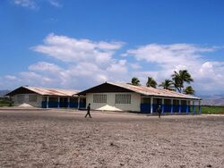
Ecole Nationale Grandes Desdunes
The Ministry of National Education of Youth and Sports is not represented in the commune of Desdunes. In the field of education, a large percentage of men and women do not know neither read nor write, and most children are not in school. The town's inventory at the time contained 34 schools, of which two are preschool level establishments, 23 primary level and 9 secondary level. The majority (27) of the schools listed are private. Two technical and vocational schools were also inventoried in the town. The school annexed to the Good Samaritan Nutrition Center welcomes around 360 students, from kindergarten to sixth grade. Ecole Salem Education EBNJ Inc, based out of Irvington, NJ, USA operates a school in the community.
Health
The Ministry of Public Health and Population is not represented in the municipality of Desdunes, however there are two health centers with beds and a clinic. In addition, two doctors and five auxiliaries provide sanitary services at commune level.
Other assistance programs are still being conducted in the town. Some of these programs involve treatments and preventive measures against various health issues such as tropical diseases and cholera. In-kind Donation of Safe Motherhood Kits, as well as Rapid Response Mechanism, are also among the programs rolled out in the small town.
Utilities
As for water availablity, one river was counted at the commune level. For the other points of water there are public fountains with nearly 210 taps. Regarding electricity, the urban part and certain localities of the municipality are electrified by a hydroelectric network provided by the Electricity of Haiti (EDH).
Security
With regard to Administrative and Judiciary Infrastructures, the municipality has a court of peace, a police station, and a civil status office.
Administration
As of December 2021


Town Hall
  Ernst Saint-Phard |
  Othniel Richemond |
  Gerty Saint-Pierre |
Socio-economic[]


News in Desdunes; man speaks about the development
Looking at the socio-economic conditions in Desdunes shows the importance of creating systems that empower individuals to be active participants in their own progress and the progress of the community. Children are especially affected during times of scarcity. The Good Samaritan nutrition center, which opened in November 2004, allows children to have a nutritious meal each day, receive medical care from a doctor, and be support from a health assistant.
To promote self-sufficiency, the staff decided to establish a vegetable garden. This garden provides some of the vegetables needed to feed the children at the nutrition center. Any extra produce is sold at the market, which helps generate profits. These profits are then used to buy more seeds and support the center financially.
It's important to understand that ever since the Nutrition Center opened in 2004, along with the various projects launched from there (like the small goat farm, vegetable garden, school, medical care for children, and a drinking water station for the village), the residents who had left the area began to realize that something significant was taking place in the village. As a result, the diaspora in New York came together to purchase poles and electrical cables to bring electricity from L'Estère to the community. It's amazing to see how those who had once abandoned the area are now returning to make it their home again.
Culture and Heritage[]
The town celebrates the feast of its patron saint, Saint Peter, annually on the 29th of September.
Religion
The community in Desdunes practices a variety of religions, with Catholics, Protestants, and Vodouists being the most common. According to IHSI data, there are approximately 65 peristyles in the commune. The GAFE survey shows that Protestantism (41%) and Vodun (40%) are the most prevalent religions, while Catholicism is practiced by 17% of the population
In Desdunes, there are over 26 temples representing different beliefs, including Catholic, Baptist, Adventist, Pentecostal, and Jehovah's Witness.
Organizations
The community also has four popular organizations, four peasant groups, two women's groups, and an international organization working towards various causes, such as combating violence against women. Some activities undertaken by NGOs include training around health, environment, culture, education, and sanitation.
Communication


Rooftop GPS station; Desdunes, Haiti
Communication infrastructure in Desdunes includes two radio stations and 9 cybercafés, but no newspaper, magazine, or television station.
Leisure
In terms of cultural and recreational facilities, the town is home to a pair of libraries, with one being privately owned, a cinema hall, two nightclubs, five gaguères, and a museum. Football stands as the most favored sport in the town. The leisure amenities are primarily concentrated in the Lagon-Penyen area, encompassing nightclubs, restaurants, gaguères, games, and public spaces. Additionally, there are some leisure facilities in the Modél locality (gaguère) and the Duclos locality (gaguère and restaurant), albeit to a lesser extent.
Twin towns and Sister cities[]
Desdunes currently has one sister city, Nantes, France.
")
")
References[]
Plan communale de dévelopment de Desdunes [1]
Presentation Desdunes [2]
Microgrid report [3]
Plan Communal de Développement de Desdunes 2016 - 2021 [4]
Michael Vedrine